 Search


- The plan is based on the principles of ecology first, protection first, restoration second, and harmony between people and water

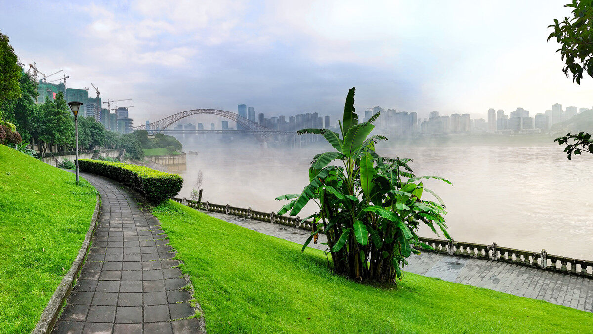
On December 1, 2021, the Chongqing Municipal Planning and Natural Resources Bureau announced that the "Chongqing Jialing Riverside Ecological Corridor Planning" has been issued. According to the "Plan", Chongqing will build the Jialing Riverside Ecological Corridor with a coastline of approximately 138 kilometers, orderly promote the improvement of the two rivers and four banks, coordinate the production, living, and ecological space of the Jialing River coastline, and combine the functional positioning of a smart city. Highlight the unique charm of a city of mountains and rivers and a beautiful place.

The Jialing Riverside Ecological Corridor starts from the Caojie Navigation and Power Hub at the junction of Beibei and Hechuan in the north, and reaches Chaotianmen in the south, involving Yuzhong District, Shapingba District, Beibei District, Jiangbei District, and Liangjiang New District. The central line of the ecological corridor is 69 kilometers long, and the shoreline on both sides is 138 kilometers long. The total area is about 48 square kilometers, of which the land area is about 25 square kilometers (calculated above the water level of 175 meters) and the water area is about 23 square kilometers. . A 122-kilometer riverside trail is planned within the ecological corridor, and citizens can enjoy the ecological beauty of the Jialing River up close in the future.
The original ecological riverside coastline
The Jialing River is the river with the largest drainage area among the tributaries of the Yangtze River. What is special about the layout of the ecological corridor? "Here is the longest original ecological riverside coastline in central Chongqing." According to the person in charge of the Municipal Planning and Natural Resources Bureau, there are 105 kilometers of original ecological coastline in the 138 kilometers of ecological corridor, accounting for about 76%. It is unique among the rivers in the city.

In addition, the 69-kilometer river course of the Jialing River within the ecological corridor meanders and twists and turns, naturally forming two gorges in Wentang Gorge and Guanyin Gorge, four backwaters in Tuokou and Jiangjiatuo, and six inhabitants in Beibei Miaozui and soil and water. Stones, 12 moraine stones such as Huangguoqi and Jianjialiang, 3 stone cliffs including Shunshui Temple and Fengqituo, 11 river beaches and natural meadows including Baihetan and Xujiatan, Zhuxi River, Houhe, etc. 17 streams, including Mahe River, flow into the estuary, and there are also many peninsulas and river bays.
The typical elements of the river gorge scenery in Chongqing, such as gorges, bays, tuo, beaches, islands, creeks, meadows, cliffs, etc., can be enjoyed within the ecological corridor. This can be said to be the "Jiangcheng Featured Landform Museum" in the downtown area.

Not only the scenery is good, but the ecological resources within the ecological corridor are also very rich. According to field surveys and expert surveys by the project team of the Municipal Planning and Design Institute, the plants within this range include protected plants such as Eucommia, Camptotheca, camphor, and ancient trees with conservation value such as Pueraria lobata and honey locust, as well as sweetroot grass, bermudagrass, five Riverside wetland plants such as Jiemeng, characteristic plants such as Jinyun Scutellaria, wild forest trees such as Masson pine, golden buckwheat and other wild key protected species, and birds such as Chinese Merganser, Heron, and Red-headed Gull.
For this reason, the "Plan" puts ecological protection and restoration at the top priority. Within the ecological corridor, 78% of the areas are ecological protection areas and ecological restoration areas, and people are prohibited from entering the area. The remaining 22% of the ecological space rational use area will also be minimally transformed through micro-utilization and other methods to maximize the beauty of nature.
According to the "Plan", the content of ecological restoration includes combining natural forest protection and vegetation restoration to create a three-dimensional scenic forest belt along the river; timely land disaster management and ecological restoration of areas with hidden dangers of landslides and exposed soil along the river; The environmental pollution of the country should be treated; the existing riverside roads, tunnel entrances, and exposed rainwater discharge outlets along the river should be greened, beautified, softened and improved.
Rational use
Several mountain balconies were added, and Binjiang Road "retreated" to leave an ecological green belt.
How can citizens appreciate the beautiful natural scenery and superior ecological resources of the ecological corridor? According to the person in charge of the Municipal Planning and Natural Resources Bureau, a total of 310 hectares of parks have been built within the ecological corridor, including the first and second phases of Golden Bay Park, Jiuqu River Wetland Park, Wucai Riverside Park, Yuelai Riverside Park, Beibei Riverside Park and so on. When citizens walk into the park, they can enjoy the river view and get close to nature.
In the future, according to the "Plan", Chongqing will pass through such as rivers and gorges, ecological island bays (Wentang Gorge, Guanyin Gorge), green mountains, meandering Huijiang, wetland meadows (Tongxing Old Street, etc.), pastoral scenery, The iconic scenes such as Qingjiang Jinshi (Beibei Temple Mouth, Golden Bay Park, etc.), Linjiang Shiya (Jiangbei Shunshui Temple, etc.), and Water Bird Xiangji constitute ecological business cards. In the future, these ecological business cards are expected to become "check-in points" for citizens.
As for where to see the best scenery, "Planning" also selected a place for the citizens. Within the ecological corridor, there will be many mountain balconies that can see the mountains and the water, highlighting the characteristics of the mountain city and the river city.

At the same time, a number of popular science camps with geological structures, wild animals and plants, and ecological technology will be built to help citizens better understand the Jialing River with the help of diversified ecological resources. In areas with relatively flat terrain, public activities such as the Riverside Marathon are also planned.
The 122-kilometer riverside trail mentioned earlier will also bring citizens closer to the Jialing River. According to the person in charge of the project team of the Municipal Planning and Design Institute, the Binjiang Trail is divided into two sections, including 92 kilometers from Ciqikou to Beibei and 30 kilometers from Ciqikou to Chaotianmen. Three levels are optimized and perfected. Except for the Wentang Gorge area which is too steep to pass through the trail, the trail basically connects to the riverside area in the ecological corridor. In order to allow citizens to better appreciate the ecological corridor, the "Planning" also proposes to allow the newly built Binjiang Road to "retreat", leave an ecological green belt, and enhance the leisure function of Binjiang Road. Slope and viaduct block the line of sight. At the same time, it combines with the ecological corridor intelligent management system to create intelligent scenes and enrich the tour experience.
City promotion
Ciqikou, Jingang Monument, Tongxing Traditional Style District, and Special Steel Plant will be further protected and upgraded.
Along the ecological corridor, there are also profound human resources. In the future, these resources will be beaded into chains for further protection and promotion.
According to the person in charge of the project team of Chongqing Planning and Design Institute, there are 3 historical and cultural blocks in the ecological corridor, Ciqikou, Jingangbei, and Chengjiang, the only public car ferry in the central city-Sansheng Ferry and other wharfs, as well as Shijialiang and Jingkou Dingjiang Town, as well as the industrial relics such as the Special Steel Factory and Jialing Machinery Factory, will show the city's connotation through iconic scenes such as the nostalgic river town and industrial memory.

Specifically, it is necessary to protect the three historical and cultural blocks of Ciqikou, Jingangbei, Chengjiang Old Street, and the traditional style district of Tongxing. It is necessary to protect Shijialiang, Shuitujingkou and other blocks, ancient towns, which have historical and cultural value, traditional style and features, and condensed cultural nostalgia. Streets and lanes and traditional buildings are systematically protected and restored to maintain the authenticity and integrity of their style and appearance. And to enhance brand benefits through riverside style renovation, river bank management, and business upgrades. Restore the water and soil wharf (Shuituoyi) and other Jiangzhen wharf ferry, retain the characteristic car ferry of Sansheng Ferry, create a water characteristic transportation node, and show the traditional cultural characteristics.
At the same time, it is necessary to protect cultural heritage such as the 24th arsenal of the war weapon industry group, historic buildings such as the old site of the special steel factory, and the industrial heritage of the relocated pharmaceutical factory complex in the War of Resistance Against Japan. Transformation and transformation of old factory areas with retained value, such as Special Steel Plant and Jialing Machinery Plant, protect the riverside industrial buildings with better construction quality, create iconic industrial fashion public spaces, stimulate the vitality of industrial heritage, and introduce cultural and creative industries. Build cultural and artistic creative districts, industrial cultural and creative parks, etc.
In addition, it is necessary to enhance the appearance of the existing buildings, optimize the skyline contours, control the height of the buildings, and control the width of the buildings along the river, strengthen the control of the shape and features of the unbuilt and untransferred land, and pay attention to the features of the facilities in the ecological corridor, the flood protection dike and other aspects. Infrastructure style management and control, etc., to enhance the style of cities along the ecological corridor.
The person in charge of the Chongqing Municipal Planning and Natural Resources Bureau stated that in the next step, the Municipal Planning and Natural Resources Bureau will cooperate with the relevant district governments to actively promote the implementation work, and build the ecological corridor into a landscape ecological picture scroll, a cultural and scenic pearl chain, and a smart recreational show belt. Editor/He Yuting
Comment

 Praise
 Collect
 Comment

 Share
Share


Write something~